Austin County
Texas Trails To The Past
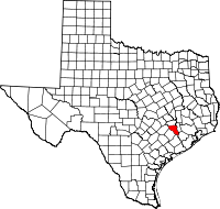 Austin County, in southeastern
Texas thirty-five miles west of Houston, is bordered on the north by
Washington County, on the east by Waller and Fort Bend counties, on the
south by Wharton County, and on the West by Colorado and Fayette
counties. Bellville, the county seat and second largest town, is fifty
miles west-northwest of Houston. The county's center point is 29°55'
north latitude, 96°18' west longitude. State Highway 36 is the major
north-south thoroughfare, while State Highway 159, U.S. Highway 90, and
Interstate 10 span the county east and west. The county is also served
by two major railways: the Union Pacific and the Burlington Northern
and Santa Fe.Austin County covers 656 square miles on the boundary
between the Post Oak Savannah and the Coastal Prairie regions of Texas.
The terrain varies from rolling hills in the northern, western, and
central sections to a nearly level coastal prairie in the south.
Elevations range from 460 feet above sea level in the northwest to 120
feet in the southeast. Most of the area lies within the drainage basin
of the Brazos River, which forms the eastern border of the county. The
margins of the western and southern sections of the county are drained
by the San Bernard River, which forms much of the county's western
border.
Austin County, in southeastern
Texas thirty-five miles west of Houston, is bordered on the north by
Washington County, on the east by Waller and Fort Bend counties, on the
south by Wharton County, and on the West by Colorado and Fayette
counties. Bellville, the county seat and second largest town, is fifty
miles west-northwest of Houston. The county's center point is 29°55'
north latitude, 96°18' west longitude. State Highway 36 is the major
north-south thoroughfare, while State Highway 159, U.S. Highway 90, and
Interstate 10 span the county east and west. The county is also served
by two major railways: the Union Pacific and the Burlington Northern
and Santa Fe.Austin County covers 656 square miles on the boundary
between the Post Oak Savannah and the Coastal Prairie regions of Texas.
The terrain varies from rolling hills in the northern, western, and
central sections to a nearly level coastal prairie in the south.
Elevations range from 460 feet above sea level in the northwest to 120
feet in the southeast. Most of the area lies within the drainage basin
of the Brazos River, which forms the eastern border of the county. The
margins of the western and southern sections of the county are drained
by the San Bernard River, which forms much of the county's western
border.
....Read More - Texas State Historical Association....
Read More Here