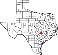
Bastrop County
 Bastrop
County, located on State highways 71, 95, 21, and 304, on the upper
Gulf coastal plains just below the Balcones Escarpment, encompasses 895
square miles of southeast central Texas. Its seat of government,
Bastrop, is situated in the center of the county at approximately
30°04' north latitude and 97°22'west longitude, a location about thirty
miles southeast of downtown Austin. The terrain throughout most of the
county is characterized by rolling uplands and broken hills with
surface layers of primarily sandy, loamy soils, and woods where post
oaks predominate but where cedar, hickory, elm, and walnut also occur.
In the northwestern corner of the county and along the central
southeastern border, the topography changes to blackland prairie with
waxy clay soil and tall grass cover. The Colorado River bisects the
county from northwest to southeast; along this waterway and its
tributaries can be found rich alluvial silts and clays. Near the river,
the Lost Pine
Forest extends through an east central section of the county.
Elevations range from 400 to 600 feet above sea level. The county's
climate has been described as subtropical humid, with a low average
January temperature of 40° F, a high average July temperature of 96° F,
and an average annual rainfall of 36.82 inches; the growing season is
270 days long. Mineral resources include clay, oil, gas, lignite, sand,
gravel, and surface and underground water.
Bastrop
County, located on State highways 71, 95, 21, and 304, on the upper
Gulf coastal plains just below the Balcones Escarpment, encompasses 895
square miles of southeast central Texas. Its seat of government,
Bastrop, is situated in the center of the county at approximately
30°04' north latitude and 97°22'west longitude, a location about thirty
miles southeast of downtown Austin. The terrain throughout most of the
county is characterized by rolling uplands and broken hills with
surface layers of primarily sandy, loamy soils, and woods where post
oaks predominate but where cedar, hickory, elm, and walnut also occur.
In the northwestern corner of the county and along the central
southeastern border, the topography changes to blackland prairie with
waxy clay soil and tall grass cover. The Colorado River bisects the
county from northwest to southeast; along this waterway and its
tributaries can be found rich alluvial silts and clays. Near the river,
the Lost Pine
Forest extends through an east central section of the county.
Elevations range from 400 to 600 feet above sea level. The county's
climate has been described as subtropical humid, with a low average
January temperature of 40° F, a high average July temperature of 96° F,
and an average annual rainfall of 36.82 inches; the growing season is
270 days long. Mineral resources include clay, oil, gas, lignite, sand,
gravel, and surface and underground water.
....Read More ....