Atascosa County
Texas Trails To The Past
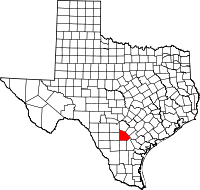 Atascosa
County (at-uhs-KO-suh) is south of
San Antonio on Interstate Highway 37 in the Rio Grande Plain region of
south central Texas. Jourdanton, the county seat, is located on state
highways 16 and 97 in central Atascosa County thirty-three miles south
of San Antonio and 100 miles northwest of Corpus Christi. The
geographic center point of the county is 28°50' N, 98°30' W. The county
covers 1,218 square miles of level to rolling land. Elevation ranges
from 350 to 700 feet, and the soils are generally deep with loamy
surface layers and clayey subsoils. Along the southern borders the
light-colored soils have limestone near the surface. In some areas the
soils are gray to black, cracking and clayey, and expand and shrink
considerably. In the South Texas Plains vegetation area, the
subtropical dry-land vegetation consists primarily of cactus, weeds,
grasses, thorny shrubs and trees such as mesquite,
and live oak and post oak. Many of the open grasslands have been seeded
with buffalo grass. Between 41 and 50 percent of the county is
considered prime farmland. Wildlife in Atascosa County includes
white-tailed deer, javelina, turkey, fox squirrel, jackrabbits, foxes,
ring-tailed cats, skunks, and opossum. The main predators are bobcats
and coyotes. Ducks, cranes, and geese migrate across the county. Tanks
are stocked with catfish, bass, and sunfish. Mineral resources include
clay, uranium, sand and gravel, and oil and gas. Other minerals and
products include caliche and clay, lignite coal, construction and
industrial sand, sulfur, and uranium.
Atascosa
County (at-uhs-KO-suh) is south of
San Antonio on Interstate Highway 37 in the Rio Grande Plain region of
south central Texas. Jourdanton, the county seat, is located on state
highways 16 and 97 in central Atascosa County thirty-three miles south
of San Antonio and 100 miles northwest of Corpus Christi. The
geographic center point of the county is 28°50' N, 98°30' W. The county
covers 1,218 square miles of level to rolling land. Elevation ranges
from 350 to 700 feet, and the soils are generally deep with loamy
surface layers and clayey subsoils. Along the southern borders the
light-colored soils have limestone near the surface. In some areas the
soils are gray to black, cracking and clayey, and expand and shrink
considerably. In the South Texas Plains vegetation area, the
subtropical dry-land vegetation consists primarily of cactus, weeds,
grasses, thorny shrubs and trees such as mesquite,
and live oak and post oak. Many of the open grasslands have been seeded
with buffalo grass. Between 41 and 50 percent of the county is
considered prime farmland. Wildlife in Atascosa County includes
white-tailed deer, javelina, turkey, fox squirrel, jackrabbits, foxes,
ring-tailed cats, skunks, and opossum. The main predators are bobcats
and coyotes. Ducks, cranes, and geese migrate across the county. Tanks
are stocked with catfish, bass, and sunfish. Mineral resources include
clay, uranium, sand and gravel, and oil and gas. Other minerals and
products include caliche and clay, lignite coal, construction and
industrial sand, sulfur, and uranium.
....Read More - Texas State Historical Association....
Read More Here